Maldives Map — Every Atoll, Located
One chain of coral atolls, almost 900 km long, in the middle of the Indian Ocean. This map shows where everything actually is — every resort atoll, the capital, the Equator — and how the geography decides whether you arrive by speedboat, seaplane or domestic flight.
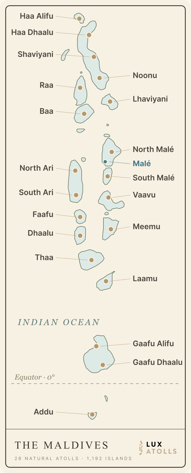
The Maldives, Atoll by Atoll
Every atoll with resorts, plotted on the real shape of the chain. Tap or click any atoll to open its full guide — resorts compared, transfers, seasons and dive sites. The capital Malé sits mid-chain; everything north and immediately south of it is speedboat-and-seaplane country, while the deep south runs on domestic flights.
Stylised chain map — not to scale · download this map as an image · every atoll guide carries its own chart plotted from real resort coordinates.
Where Is the Maldives?
The Maldives lies in the Indian Ocean, south-west of the Indian subcontinent — roughly 750 km from Sri Lanka and 600 km from the southern tip of India. On a world map, find Sri Lanka and look down and to the left: the thin scatter of islands running toward (and just across) the Equator is the Maldives.
The chain stretches almost 900 km from Ihavandhippolhu in the far north (about 7°N) to Addu Atoll at 0.6°S, yet it is never more than ~130 km wide. The capital Malé and Velana International Airport (MLE) sit near the midpoint at 4°10′N, 73°30′E — which is why every trip starts mid-chain and radiates outward. The Maldives is a fully independent republic (since 1965), and it runs on its own clock: UTC+5.
Flight times to Malé
| From | Time in the air | Notes |
|---|---|---|
| Colombo | ≈ 1 h 25 m | Shortest international hop |
| Dubai | ≈ 4 h 15 m | Several nonstops daily |
| Doha | ≈ 4 h 45 m | Nonstop |
| Singapore | ≈ 4 h 35 m | Nonstop |
| Delhi / Mumbai | ≈ 3–4 h | Nonstop |
| Istanbul | ≈ 8 h | Nonstop |
| London | ≈ 10 h 20 m | Seasonal nonstop; otherwise one stop via the Gulf |
| New York | ≈ 18–20 h | No nonstop — one stop via the Gulf or Europe |
Once you land, the map below the aircraft window takes over: your resort's atoll determines the second leg. The full logistics live in our getting-to-the-Maldives guide.
The 20 Resort Atolls on the Map
The Maldives counts 26 natural atolls, organised into 20 administrative atolls — and 20 atolls currently host resorts. Each one is a ring of reef and islands with its own personality: manta seasons in Baa, whale sharks in South Ari, speedboat convenience around Malé, equator-crossing remoteness in the deep south. Every atoll below links to a full guide; for the side-by-side comparison, see the Maldives atolls guide.
How the Map Translates to Transfers
There are no roads between atolls — the map is the transfer plan. Distance from Malé sorts the country into three zones:
North Malé and South Malé Atolls — 15 to 60 minutes from the airport, running day and night. The only zone where a midnight landing still gets you to your island.
Baa, Raa, Noonu, Lhaviyani, both Aris, Dhaalu and their neighbours — scenic 25–60 minute flights, daylight-only, landing on the lagoon itself.
Hanimaadhoo serves the far north; Kooddoo, Kaadedhdhoo and Gan serve the Gaafus and Addu — 55–90 minute flights with a speedboat at the other end, and evening rotations that work after dark.
Transfer cost and time per atoll are compared in each atoll guide, and the booking mechanics — who arranges what, and when — are in the transfer guide.
Maldives Map Questions, Answered
The Maldives sits in the Indian Ocean, roughly 750 km south-west of Sri Lanka and about 600 km from the southern tip of India. The island chain runs almost 900 km north to south — from about 7°N down across the Equator — with the capital Malé near its midpoint at 4°10′N, 73°30′E.
No — the Maldives is a fully independent republic, and has been since 1965. It's India's closest island neighbour after Sri Lanka, but it has its own government, language (Dhivehi) and currency (the rufiyaa), with Malé as the capital.
Around 1,192 coral islands, grouped into 26 natural atolls. Only about 187 are inhabited local islands, and roughly 170 more operate as one-island, one-resort properties — the rest are uninhabited.
Yes. The Equator crosses the far south of the chain — between the huge Huvadhoo Atoll (Gaafu Alifu and Gaafu Dhaalu) and Fuvahmulah. Fuvahmulah and Addu are the only parts of the country in the southern hemisphere, and Addu is the only resort atoll below the line.
It depends how you count: the islands themselves add up to barely 300 km² of land — one of the world's smallest countries — but they're scattered across roughly 90,000 km² of ocean. That 99%-water geography is why getting between atolls means a speedboat, seaplane or domestic flight rather than a road.
Ready to start planning?
Now that you know where everything is — compare the resorts that sit on it. Honest reviews, villa breakdowns and exclusive packages across all 20 atolls.
Explore All Resorts